It’s always good to mix things up a little, and there’s rarely only one way to get from Point A to Point B. My plan for last Saturday involved joining Matthew and Gabriel at the garden during the morning hours, then biking home after lunch.
As I’ve mentioned before, trips to my in-laws’ in the suburbs are probably the primary use for our car. My MIL’s (where we garden), is about 11 miles away, which translates to about 25 minutes by car vs. an hour (or more) by bike. We’ve biked there a few times, but the time differential (between car and bicycle) makes it pretty impractical, a lot of the time.
Our previous bike route involved mostly small streets, and a couple of big hills. I was curious about an alternate route using larger arterial streets, for a more direct and faster ride (fewer stop signs). Lo and behold, my planning led me to . . .
. . . a bike trail! And not just any bike trail, but Grant’s trail, probably St. Louis’ most well-known multi-use trail.
In my nine (!) years of cycling in St. Louis, I had never set foot (or bicycle wheel) on Grant’s Trail until Saturday. With it’s mostly south-county location, and my biking for transportation, rather than recreation, it’s never been particularly useful to me (ditto for other local-ish bike trails), but there it was, offering a nice option for connecting my route home from the garden.
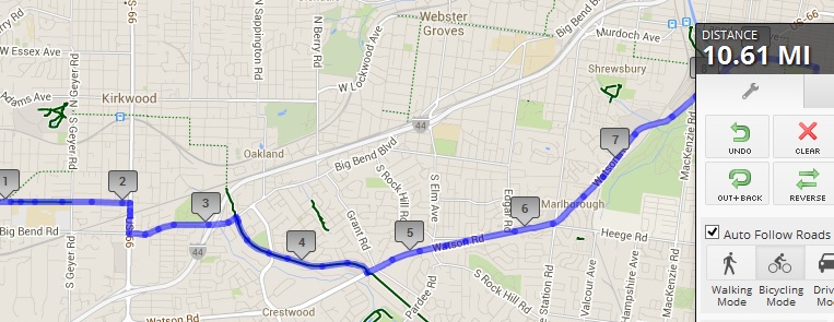
Here’s a snapshot of Saturday’s route. Connecting to Grant’s Trail was easy. I rode on Big Bend (arterial) for a relatively short stretch to connect to the trail, just after mile marker 3 on the map. I was on the trail for about a mile (between Big Bend and Watson Road), and I must say, it was rather lovely. I’ve heard other cyclists complain that the trail is packed to the point of being difficult to ride on weekends, but that was not the case, even on a lovely Saturday afternoon at the end of April.
Then came Watson Road, a major suburban arterial. In general, I use arterials for short distances (1/2 mile or less?) to connect other parts of my routes. But, thanks to the lack of street grids that is the suburbs, my route on Saturday involved 3.5 miles on Watson.
It was fast, compared to smaller streets. I rode in the middle of the right lane, where I was nice and visible, the whole way. The relatively narrow lanes made it easy to control my space, and motorists had the entire left lane in which to pass. Traffic was rather heavy, but, in general, followed the expected pattern, with a big platoon, followed by just me on an almost empty road.
It was on the almost empty road sections that I observed the strangest motorist behavior. Multiple times, a motorist approached in the right lane, and, with no other cars with us on that stretch, had all the time and space in the world to move into the left lane and pass me without ever taking his/her foot off of the gas pedal.
Instead, many got relatively close and slowed down before finally changing lanes. I’m not sure what these motorists were thinking. It felt like they thought maybe, if they didn’t react to my presence I would just, I don’t know, vaporize? Suddenly swerve onto the narrow (or nonexistent) shoulder so they could pass without changing lanes? I really wonder what was going through their heads.
None of these puzzling passers displayed any incivility, and they all made full lane changes and passed safely in the end, but it was odd. After a few such instances, I started proactively waving overtaking motorists into the left lane before they had to slow down to make the lane change.
The only instance of incivility I had in those 3.5 miles (or in the entire 10.6 miles, for that matter), was a honker (AKA “barking dog”) who wanted to beat me to a red light. His prize? Getting to sit at the red light longer!
I was hoping to make the trip in under an hour. Of course, I forgot to look at the clock at either the very beginning or very end of my ride, but I think I made it in 45-50 minutes.
When I got home, I did some mapping, and was surprised to see that my more “direct” route was actually a tenth of a mile longer (10.6 miles vs. 10.5 miles) than my previous, lower-key streets route. Also, both of the bike routes are shorter, distance-wise, than our driving route, which is 11.2 miles. On the other hand, Google map’s suggested “bike” route, which winds through some of those horribly convoluted small streets in the ‘burbs, was 12.2 miles, over a mile-and-a-half longer than either of my bike routes!
All-in-all, it was a good ride. I pushed myself fairly hard, given my current conditioning level, and the fact that it was rather warm. I would certainly not always choose the route with 3.5 continuous arterial miles (especially since the other route is equidistant (if slower)), but it was fun to challenge myself and try something new.


“…[i]nstead, many got relatively close and slowed down before finally changing lanes[…]I started proactively waving overtaking motorists into the left lane before they had to slow down to make the lane change.”
This is definitely my experience on the county arterials. A lot of waving around. I don’t mind as much when people are going 25mph or so, but over 35mph, the difference between them and me is pretty substantial. I’m not sure if that would be made better or worse by the relatively uncrowded experience on Watson (versus Saturday’s nearly bumper-to-bumper traffic on an artery such as Manchester).
I really like Grant’s Trail. I wish they would create more trails like it that connect the burbs to city centers in Clayton, or to attractions like Forest Park. It can be very busy (or overrun with children who aren’t been adequately supervised), but I’d rather dodge an unpredictable toddler than have a 2-ton vehicle dodge me… 😉
Truly bumper-to-bumper traffic, combined with frequent traffic signals, can actually mitigate some of the speed differential, by slowing everyone down, but you know your section of Manchester better than I do.
As I mentioned in my comment to Cat, I was paying a lot of attention and very actively monitoring the traffic behind me, which allowed me to start waving the motorists over to the left lane while they were still quite a ways behind me. It also allowed me to gauge motorist attention level. If I’d been waving someone over, and he/she just wasn’t responding, I could have taken avoidance measures.
Grant’s Trail works, in large part, because of the subdivisions, with cul-de-sacs and other roads that don’t connect. If there were a grid system in most of the area that the trail covers, there would be too many intersections to make the trail practical, so it’s kind-of a catch-22.
You are SOOOO much braver than I am, the mere idea of riding on an arterial just scares the begeezus out of me. Of course the ones in my area have a LOT of traffic any time of day. They’re practically like freeways – six lanes, speed limit of 45 with lots of impatient drivers weaving in and out of traffic – major hills & valleys, so you can’t really see more than about 50 yards ahead – you generally have to wait a few minutes even to make a right turn onto one of these streets (in a car), and making a left turn is next to impossible without a light. I avoid them even in the car, I just can’t imagine trying to ride a bike on a street like that. Come to think of it, I’ve never actually seen anyone riding a bike on one of them – but people must do it because there have been 6 pedestrians & cyclists killed on the 2 arterials that my home sits between in just the past few months.
I feel like I leave almost the same comment every time you write about riding on streets like this, and I’m really NOT trying to be a detractor, but seriously, I’m just incredulous. Could it be that the “arterials” you describe are qualitatively different from the ones in my area? Do you think it’s just that Denver doesn’t have the same sort of cycling culture that St. Louis does? I just can’t even imagine cars slowing down enough to see you before they mowed you over… is there some secret trick to this sort of thing? I honestly just can’t figure out how this could possibly be accomplished without instant death.
Anyhow, if you’d ever consider writing a post on this topic, I’d love to actually understand how this sort of thing is even possible.
Cat, I would love to be able to cover this topic in a post, but it’s rather impossible (even if the information wasn’t copy-righted), since it’s based on a very comprehensive 9-hour course that includes significant on-bike time, including solo riding. There really are some things you can’t learn in a classroom, or by reading.
The arterial I rode on was a bit different than the ones you describe: 4-lanes and a 40mph speed limit, yet the principals I practice would still apply. Also, as I mentioned, I don’t usually use big, higher-speed arterials for that kind of continuous distance — it did require WORK, monitoring overtaking traffic. In the course, we teach some “tricks” (information about signal timing, traffic flow, etc.) to help people learn ways use larger roads to connect smaller, lower traffic streets.
Hmmm… well, you mention monitoring overtaking traffic. Perhaps a rear-view mirror would be a good place to start.
Matthew (and a number of our bikey friends) really like the Safe Zone helmet mirror. I have not tried it, but it may be worth a go.
I have a bar-end mounted mirror on Baby Jake. It can be useful, but I often feel I have to spend so much time getting it adjusted “just so,” to actually show much of anything, that it’s more trouble than it’s worth (I’ve often thought that it would be very ironic if I crashed while adjusting my mirror). I did use it a bit on this ride, but I was mostly using the good, old-fashioned shoulder check.