It’s always good to mix things up a little, and there’s rarely only one way to get from Point A to Point B. My plan for last Saturday involved joining Matthew and Gabriel at the garden during the morning hours, then biking home after lunch.
As I’ve mentioned before, trips to my in-laws’ in the suburbs are probably the primary use for our car. My MIL’s (where we garden), is about 11 miles away, which translates to about 25 minutes by car vs. an hour (or more) by bike. We’ve biked there a few times, but the time differential (between car and bicycle) makes it pretty impractical, a lot of the time.
Our previous bike route involved mostly small streets, and a couple of big hills. I was curious about an alternate route using larger arterial streets, for a more direct and faster ride (fewer stop signs). Lo and behold, my planning led me to . . .
. . . a bike trail! And not just any bike trail, but Grant’s trail, probably St. Louis’ most well-known multi-use trail.
In my nine (!) years of cycling in St. Louis, I had never set foot (or bicycle wheel) on Grant’s Trail until Saturday. With it’s mostly south-county location, and my biking for transportation, rather than recreation, it’s never been particularly useful to me (ditto for other local-ish bike trails), but there it was, offering a nice option for connecting my route home from the garden.
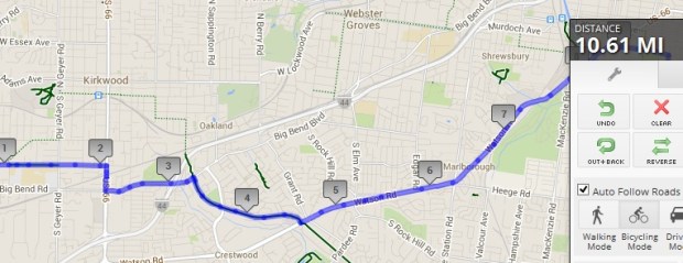
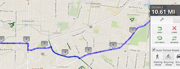
Here’s a snapshot of Saturday’s route. Connecting to Grant’s Trail was easy. I rode on Big Bend (arterial) for a relatively short stretch to connect to the trail, just after mile marker 3 on the map. I was on the trail for about a mile (between Big Bend and Watson Road), and I must say, it was rather lovely. I’ve heard other cyclists complain that the trail is packed to the point of being difficult to ride on weekends, but that was not the case, even on a lovely Saturday afternoon at the end of April.
Then came Watson Road, a major suburban arterial. In general, I use arterials for short distances (1/2 mile or less?) to connect other parts of my routes. But, thanks to the lack of street grids that is the suburbs, my route on Saturday involved 3.5 miles on Watson.
It was fast, compared to smaller streets. I rode in the middle of the right lane, where I was nice and visible, the whole way. The relatively narrow lanes made it easy to control my space, and motorists had the entire left lane in which to pass. Traffic was rather heavy, but, in general, followed the expected pattern, with a big platoon, followed by just me on an almost empty road.
It was on the almost empty road sections that I observed the strangest motorist behavior. Multiple times, a motorist approached in the right lane, and, with no other cars with us on that stretch, had all the time and space in the world to move into the left lane and pass me without ever taking his/her foot off of the gas pedal.
Instead, many got relatively close and slowed down before finally changing lanes. I’m not sure what these motorists were thinking. It felt like they thought maybe, if they didn’t react to my presence I would just, I don’t know, vaporize? Suddenly swerve onto the narrow (or nonexistent) shoulder so they could pass without changing lanes? I really wonder what was going through their heads.
None of these puzzling passers displayed any incivility, and they all made full lane changes and passed safely in the end, but it was odd. After a few such instances, I started proactively waving overtaking motorists into the left lane before they had to slow down to make the lane change.
The only instance of incivility I had in those 3.5 miles (or in the entire 10.6 miles, for that matter), was a honker (AKA “barking dog”) who wanted to beat me to a red light. His prize? Getting to sit at the red light longer!
I was hoping to make the trip in under an hour. Of course, I forgot to look at the clock at either the very beginning or very end of my ride, but I think I made it in 45-50 minutes.
When I got home, I did some mapping, and was surprised to see that my more “direct” route was actually a tenth of a mile longer (10.6 miles vs. 10.5 miles) than my previous, lower-key streets route. Also, both of the bike routes are shorter, distance-wise, than our driving route, which is 11.2 miles. On the other hand, Google map’s suggested “bike” route, which winds through some of those horribly convoluted small streets in the ‘burbs, was 12.2 miles, over a mile-and-a-half longer than either of my bike routes!
All-in-all, it was a good ride. I pushed myself fairly hard, given my current conditioning level, and the fact that it was rather warm. I would certainly not always choose the route with 3.5 continuous arterial miles (especially since the other route is equidistant (if slower)), but it was fun to challenge myself and try something new.
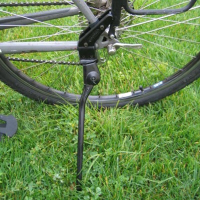 Due to the placement of the rear shifting cable, I can’t use what I would call a traditional, bottom-mounted plate kickstand on Baby Jake. I’d looked at Greenfield Rear Mount Kickstand before, but it didn’t play nicely with the trailer hitch. But no more trailer means this kickstand is now a go!
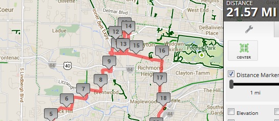


